
A cooler Tuesday, mostly cloudy and windy, with scattered showers all around.
This morning we wake up to more comfortable temperatures in the 70s. Highs today will struggle to reach the mid 70s due to overcast skies and rain at times.
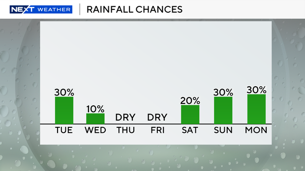
Lingering moisture coupled with a blocked frontal boundary to the south will keep us unsettled today with the possibility of passing showers and storms this afternoon and evening.
The breeze will strengthen, making beaches and sailing conditions dangerous. There is a high and dangerous risk of rip currents along Atlantic beaches.
A small craft advisory has been issued for boaters on Atlantic waters due to northeast winds of 15 to 20 miles per hour and rough conditions in the bays.
Small craft should use caution in the Keys with rough conditions near shore.
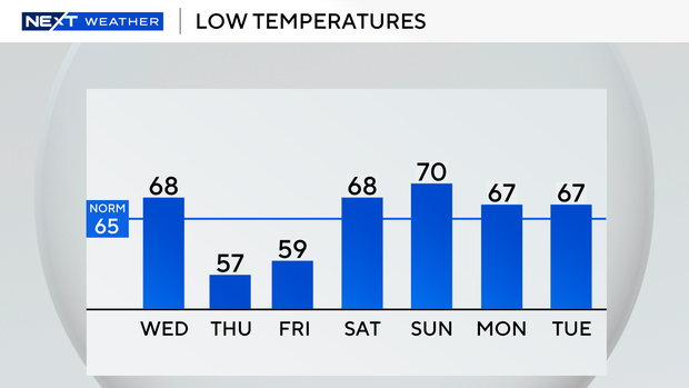
Wednesday morning will be slightly cooler with lows in the upper 60s.
Highs will reach around 80 degrees under mostly sunny skies.
The chance of rain is low on Wednesday with only scattered showers possible.
A stronger cold front will move in and bring in even cooler air.
It will be a cool start Thursday morning, with lows falling mostly in the mid to upper 50s. Humidity will also decrease significantly.
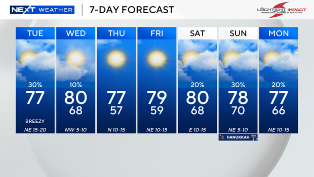
As high pressure dominates our weather pattern into the end of the week, we will enjoy cool mornings and pleasant afternoons with highs in the upper 70s Thursday and Friday.
This weekend we warm up slightly with highs in the 80s and chances of spotty showers.


