California experiences first widespread rain and heavy snow of the season in the Sierra

First significant rain and snow for California
California is experiencing its first widespread deluges of the season, which will also include the Sierra’s heaviest snowfall so far this fall.
This is happening now
This storm system is currently plunging south along the California coast.
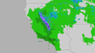
The radar and satellite image below shows where the system is currently located. Rain and some high mountain snow spread south across the state. In some areas, these rains are locally heavy, as shown by the yellow and red contours on the radar map below.

Weather alerts
Flood warnings have been issued by the National Weather Service for parts of central and southern California. This includes parts of the Los Angeles Basin and the southern Sierra foothills.
Winter storm warnings are also in effect in the Sierra, generally above 6,000 feet.

Storm Calendar
This system will evolve quickly.
It will rain across much of Northern California for the remainder of the day Monday.
Rain will then spread to Southern California Tuesday morning, then transition to showers Tuesday afternoon. This could lead to difficult travel on Tuesday with wet roads in the Los Angeles Basin, especially in the morning.
Sierra snow is expected to intensify Tuesday, then persist through Tuesday evening before ending.

Potential impacts
Rain
Locally heavy rain, exceeding 1 inch, is possible in parts of California through Tuesday. This is especially the case in the Sierra foothills, below snow level (below 5,000 feet), and in the foothills and uplands of Southern California.
In these locations, flash flooding could occur and some minor debris flows are possible near areas recently burned by wildfires.
Typical flooding of streets and highway exits is also possible.
Snow
In the Sierra, snow will generally fall at elevations above 5,500 feet, where 1 to 3 feet of total snow may occur through Tuesday evening or early Wednesday morning. A few inches of snow may also accumulate up to Lake Tahoe level.
This heavy snow and strong winds on the ridge tops could lead to suddenly reduced visibility and difficult travel on Donner Summit, among other Sierra passes. Power outages and tree damage are also possible due to the weight of this early season wet snow and the strength of strong wind gusts.
Consider avoiding travel to the Sierra during the storm.

Upcoming rainy season
California has distinct wet and dry seasons.
That’s because the jet stream that typically sends strong Pacific storms to the West Coast and California is weakening and moving well north in summer.
Fall is the time of transition in California. Sometimes strong Santa Ana winds fan large wildfires in October.
But sometimes, Pacific storm systems can sag far enough south to spread rain to at least Northern California, and even as far south as Los Angeles and San Diego.
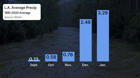
About 82% of the average precipitation in Los Angeles falls from December to March. This often happens when strong Pacific storms pick up deep plumes of moisture called atmospheric rivers.
Jonathan Erdman is a senior meteorologist at Weather.com and has covered national and international weather since 1996. Extreme and bizarre weather are his favorite topics. Contact him on Blue sky, X (formerly Twitter) And Facebook.


 Game Recap")

