
These cities have a chance at a white Christmas
A white Christmas is only likely in the usual places in the upper Midwest and mountain West, but its chances are on the rise for parts of the Northeast.
How it is defined: Meteorologists define a “white Christmas” as having at least 1 inch of snow on the ground on Christmas morning.
It’s snow blanketno snowfall, that matters. So if there is no snow on the ground in the morning and an inch of snow falls that afternoon or evening, it does not count as a white Christmas.
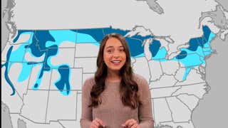
The latest forecasts: The map below shows our latest forecast. Areas within the darkest teal outline have the best chance of having at least 1 inch of snow cover on Christmas morning. Those in the light teal shade have a chance, but it’s not a guarantee.
The ones in the gray outline, well, you might want one next year.
This forecast could change in the days leading up to Christmas morning. But we expect this general shape of the Christmas snow cover.
Snow cover may be very close to last Christmas, which was less extensive than average, with only 26% of the country having snow on the ground, according to NOAA.
(MORE: A Brief History of White Christmas)

A change in the Northeast: Our latest update brought the “possible” contour south along parts of the I-95 corridor, including southern New England, the New York tristate, and much of Pennsylvania, including Philadelphia.
Indeed, two weather systems could bring snow, sleet or ice to the Northeast next week. The first could arrive Tuesday, mainly in the Hudson Valley and New England. The second could arrive as early as Christmas Day, a little further south.
The details of these forecasts, particularly for the second system, remain very uncertain and subject to change. But this introduces at least a “chance” of 1 inch of snow cover in these areas.
Last year, New York’s Central Park celebrated its first white Christmas in 15 years.
(CARDS: Daily U.S. Rain and Snow Forecast)
What about all the current snow cover: This prospect may make some of you scratch your heads.
Parts of the Mid-Atlantic Corridor and I-95 saw their first snow of the season last weekend. And it’s been a snowy spell since the weekend after Thanksgiving across part of the Midwest, from Iowa and the Ohio Valley to the Great Lakes. Springfield, Illinois (18.9 inches) is experiencing its snowiest start to the “winter season” since 1893, with almost as much snowfall as the average for an entire season through spring (21.8 inches).
Chicago’s O’Hare Airport received almost as much snow as all of last season, and it’s only mid-December.
It was also one of the coldest first 10 halves of December on record for several Midwest and Eastern cities, including Green Bay, Wisconsin, Cleveland and Scranton, Pennsylvania, according to the Southeast Regional Climate Center.
(MAP: Where is the snow cover now?)
Warmer trend: First, a general warming trend is beginning across much of the country and will continue through Christmas week. This includes the snowy and recently cold Midwest.
Yes, there will be cold fronts in the coming days. But these cold air intrusions are expected to be increasingly localized in the northern portion and will not last as long as recent cold snaps in most areas.
This is one reason we expect the extent of snow cover in the Midwest to erode by the holidays.
An exception to this rule might be the Northeast, particularly parts of New England, where stubbornly cool air can last into Christmas week and beyond.
(CARDS: Current weather | 10-day high/low forecast)

NOAA 6-10 Day Temperature Forecast
Where snow can fall until Christmas: Given this warmer trend, we don’t expect much snow in the eastern two-thirds of the country, except near the Canadian border and the Great Lakes snowbelt.
But it’s not bad news if you like a white Christmas.
We expect more snow in the Western Mountains through Christmas, as shown in the map below. This is especially the case in the Cascades, Sierra, and northern Rockies, where recent record-breaking heat and atmospheric torrential rains have significantly depleted the snowpack. So if you spend Christmas on a ski slope in these parts, you might feel like Santa has kept his promises.

Outlook for snowfall potential through Christmas
Jonathan Erdman is a senior meteorologist at Weather.com and has covered national and international weather since 1996. Extreme and bizarre weather are his favorite topics. Contact him on Blue sky, X (formerly Twitter) And Facebook.


:max_bytes(150000):strip_icc():focal(736x258:738x260)/sam-smith-met-gala-new-york-050624_4117-cd59bf2ab0944ac6aeb8604bfb5ac3bb.jpg?w=390&resize=390,220&ssl=1 "Sam Smith had liposuction at 13 after being bullied")
