
UPDATE – 1 a.m. Sunday: Although a few scattered showers have moved through the area, the main line of thunderstorms remains west of Baton Rouge. So far, the strongest storms have occurred on the southern flank of this line. Several severe thunderstorm and tornado warnings have been issued for parts of southwest Louisiana over the past few hours. In fact, probable tornado damage was also reported in Sulfur, LA.
There have been signs of these storms weakening during recent radar analyses. But conditions can still change, so it’s not yet time to get comfortable. The line of storms is still on track to pass through the Capital Region between 2 and 5 a.m.
The National Weather Service has issued a ***TORNADO WATCH*** for East Baton Rouge, West Baton Rouge, Ascension, Assumption, Iberville, East Feliciana, Livingston, Pointe Coupee, St. Helena, St. James, St. Mary and West Feliciana parishes, as well as Amite and Wilkinson counties until 6 a.m. Sunday.
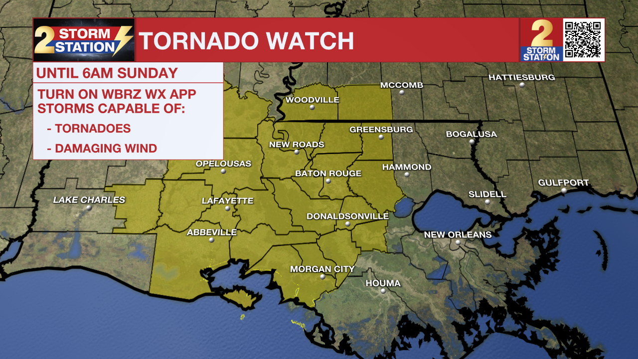
A TORNADO WATCH means conditions are favorable for tornadoes and/or damaging winds in and around the watch area. Be on the lookout for threatening weather conditions and listen for subsequent statements and possible warnings. If a tornado warning is issued, seek shelter in a low interior room of a sturdy building. Take pets (on a leash) with you, wear hard-soled shoes, monitor storm coverage on a wireless device, and cover your head in case of wind or tornado impact. To learn more about tornado safety, CLICK HERE.
A broad line of storms will invade the Capital Region after midnight, likely between 2 and 5 a.m. Beforehand, an isolated activity will develop upstream of the main line.
Any of the late night storms could end up being strong to severe, with damaging winds and isolated, brief tornadoes being the main concerns. While the vast majority won’t experience extreme weather, a few unlucky places might. So make sure you have a way to receive weather alerts before bed, in case a severe thunderstorm or tornado warning is issued in your neighborhood. In total, an additional 1-3″ of rain is expected, but a few spot locations may see higher totals. This should be a beneficial soak for most locations, provided it doesn’t fall too quickly.
Sunday: Although overnight showers and thunderstorms may persist into the early morning hours, the rain will quickly clear out after sunrise. Nothing more than an occasional thunderstorm is expected this afternoon. Skies will also show signs of clearing, helping to push high temperatures closer to 80°.
Following : Rain will be harder to come by early next week. Humidity will retreat to more comfortable levels, with highs near 80° and lows hovering either side of 60°, depending on the day. A strong cold front is expected to pass through Tuesday evening, with only a slight chance of passing showers overnight. But the biggest problem will be falling temperatures behind the front. Daytime highs will fall into the 60s Wednesday and Thursday, with lows reaching the mid-40s by the end of the week. Halloween appears to be cooler this year, with temperatures dropping into the 60s and 50s during trick-or-treating.
The Tropics: Hurricane Melissa rapidly intensified into a major hurricane Saturday evening while beginning to drift westward just south of Jamaica. Intensification will continue and Melissa could become a Category 5 storm by Monday. Early next week, the storm will track north toward Jamaica, where a landfall appears increasingly likely. A multi-day period of damaging winds, heavy rain and storm surge is expected, leading to catastrophic and life-threatening flash floods and numerous landslides. After hitting Jamaica, Melissa is expected to head towards eastern Cuba, the southeastern Bahamas and the Turks and Caicos Islands.

Get the latest 7-day forecast and real-time weather updates HERE.
Watch the news live HERE.
— Meteorologist Malcolm Byron
The Storm Station is there for you, on every platform. Your weather updates are available on News 2, wbrz.com and on the WBRZ WX app on your Apple or Android device. Follow WBRZ Weather on Facebook and X for even more weather updates while you’re on the go.


